Torridon is a mountain walker’s dream, an ancient rock playground which contains some of the country’s finest peaks, writes Alan Rowan.
Most head for the Munro leviathans of Beinn Alligin, Beinn Eighe and Liathach, each more of a mini mountain range than a single hill with series of tops stretching along their rugged spines.
However, there is much more to this area than the big three. There are rich pickings to be had among the multitude of Corbetts and Grahams scattered amongst the giants.
One of the finest and less celebrated of the smaller satellite summits is Beinn a’ Chearcaill, a modest hill that manages to pack in a lot of surprises.
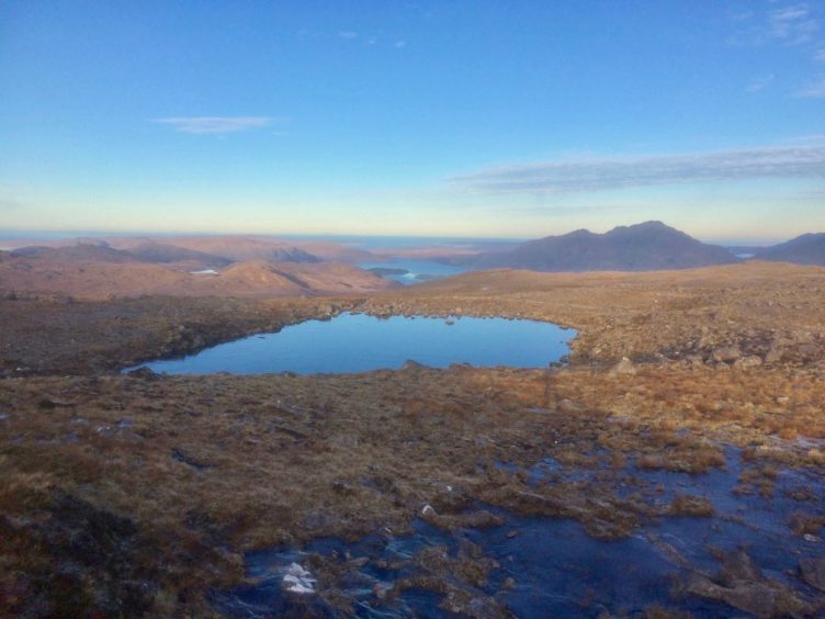
Sitting in the Flowerdale Forest at a height of 752 metres, it reveals unusual views of its lofty neighbours. There’s also the lovely trek weaving through a series of little lochans to enhance the continuous mountain peep show.
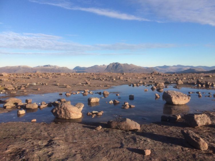
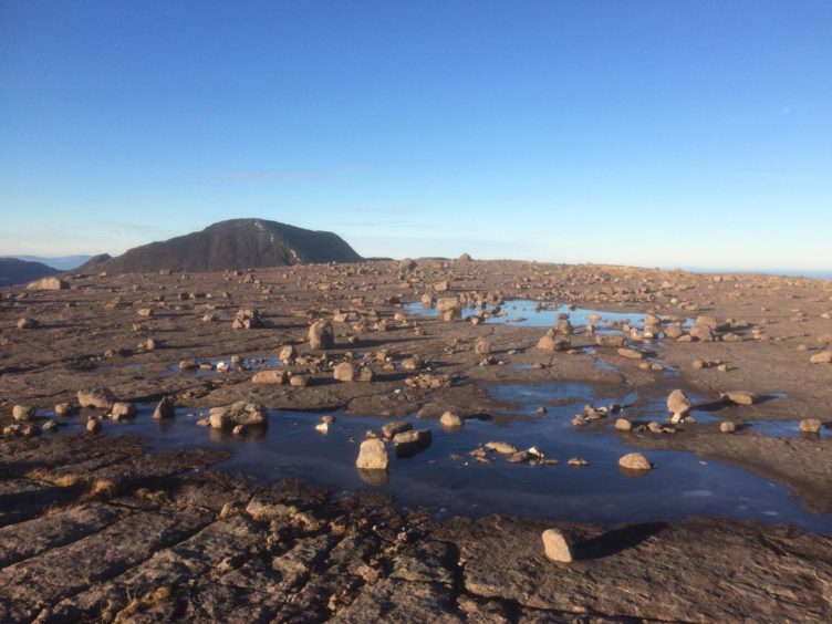
But the real wow factor arrives when you climb on to its remarkable summit plateau, a long, flat sandstone runway littered with hundreds of free-standing boulders. Even in a landscape as unique as Torridon, its alien vibe takes the breath away.
This has become a favourite walk whenever I’m in this area and fancy a shorter day, and I’m already looking ahead to when we can travel freely again to make a return visit.
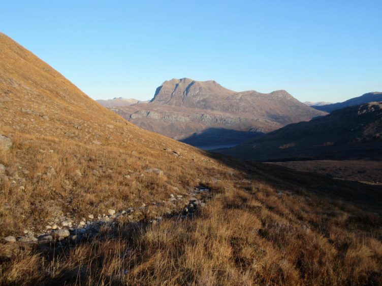
My route started from an old stretch of road off the A832 just west of Bridge of Grudie, across the waters of Loch Maree and the grand rock ramparts of Slioch.
I walked up past the fairly modern white house to pick up a fine stalker’s path heading up Glen Grudie. A substantial cairn marked the turning point just before the path started to dip into Coire Briste, and I followed the right-hand branch which contoured round the walls of the corrie until it ran out at a lively stream.
Large blocks made it an easy hop across the water, and then it was just a case of keeping the line to the summit of Beinn a’ Chearcaill, two kilometres distant.
The ground ahead is rough and pathless but never lacks interest; every so often there is another lochan to weave your way round, another small boulder field to negotiate, and there are constant glimpses of old friends from unfamiliar angles round every corner, a sustained game of Guess the Peak.
The moment when you emerge on to the final plateau never fails to thrill. There’s a few seconds’ pause to drink it all in, before heading out to the western edge and the big summit cairn perched above a precipitous face. The emptiness of the glen below was stark, the light picking up every silver vein as each found its way to the mother stream to snake down to the loch.
Beinn a’ Chearcaill is the “hill of the circle” and the name is apt for the delights of its 360-degree vista. Directly across from the cairn sat Beinn an Eoin, and to the south-west Beinn Alligin, the jewelled mountain, its Horns prominent behind the bulk of that nearly Munro, Beinn Dearg.
I returned through the boulders and picked a lunch spot at the other end of the cracked sandstone sheet, my seat providing the best view yet, a perfect line of vision into the magnificent Coire Mhic Fhearchair of Beinn Eighe, and the serrated skyline of Liathach.
Even on descent the views kept coming, the Fisherfield Munros of the Great Wilderness lining the horizon, and always to the forefront Slioch. It seemed to fit in a frame from every angle, looking particularly fine as a glowing giant in the distance contrasting with the frozen lochans that now lay in the late afternoon shadows.
The inward route can be re-traced but if time and inclination allow, you can vary the return by cutting off the path after crossing the stream and make the short climb north to the subsidiary peak of A’ Choineach Beag.
In clear weather the way down is obvious but if in doubt err to the right to avoid a small band of crags before picking up the stalker’s path further down. And, of course, Slioch will guide you home.
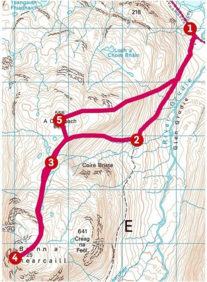
Route:
1. Leaving parking area, turn right and past white cottage to pick up good stalker’s path heading south in Glen Grudie.
2. After about 2km, turn right at a prominent marker cairn (NG 953661) and follow this branch of the path as it curves south-west round the contours of Coire Briste to reach a stream near a lochan.
3. Cross the stream and keep going south over pathless terrain, weaving your way through a series of lochans to eventually reach the rock-strewn summit plateau. The huge cairn is at the western end.
4. Retrace your steps for the 2km back to the stream, and pass west of a lochan to head north to top of A’ Choineach Beag.
5. Drop east-north-east from summit for 1km to a spur and then north-east to reach the stalker’s path and follow back to the start.
The Lowdown:
Distance: 12km/7.5 miles
Ascent: 740m/2,428ft
Time: 4-6 hours
Grading: Mountain paths and rough terrain, strenuous walk for fit and experienced walkers with relevant seasonal skills.
Start/finish: Parking off A832 west of Bridge of Grudie on old section of road (Grid ref: NG 962680).
Map: Ordnance Survey 1:50,000 Landranger Map 19 (Gairloch & Ullapool); Ordnance Survey 1:25,000 Explorer sheet 433.
Tourist Information: VisitScotland, Ullapool iCentre, Argyle Street, Ullapool, IV26 2UB (Tel 01854 612486).
Public transport: Buses between Inverness and Ullapool (no official stop at Bridge of Grudie).
Alan Rowan is a well-known author and walker. You can follow his regular mountain adventures @munromoonwalker.com
• Please observe government coronavirus safety guidelines in all outdoor activities.
