Carn Bhac, Braemar, Cairngorms
Carn Bhac is often regarded as one of the less interesting Munros – unfairly in my opinion – mainly due to the oft-used route which tags it on to Beinn Iutharn Mhor and a weary trudge through peat hags.
Give it a bit of breathing space, however, and you can enjoy a fine circuit through two glens and over a series of summits. It’s a long walk, some 15 miles, but it never feels too strenuous.
The starting point is the car park directly across from the row of houses at Inverey. One famous former resident was Maggie Gruer, who provided bed and breakfast to climbers and walkers in the 1930s. Politicians, playwrights and poets were also among her admirers.
There’s a memorial in the car park to John Lamont, a native of Deeside who became Astronomer Royal of Bavaria during the 1800s. The Apollo Moon mission landed at a spot named Lamont in the Sea of Tranquillity and there’s a mountain on Mars that also bears his name.
A short walk west along the road takes you past a red phone box and over a stone bridge to reach a track on the left which heads south by an amalgamation of streams that flow down into the Dee. Sticking with the main track leads at a lazy angle all the way to its end on the horizon.
The top of Carn Liath is a short diversion to the right, but the main route now turns left, a path, faint at times, leading over a series of rises to the stony little prominence of Geal Charn. The views to distant Beinn a’ Ghlo are particularly fine.
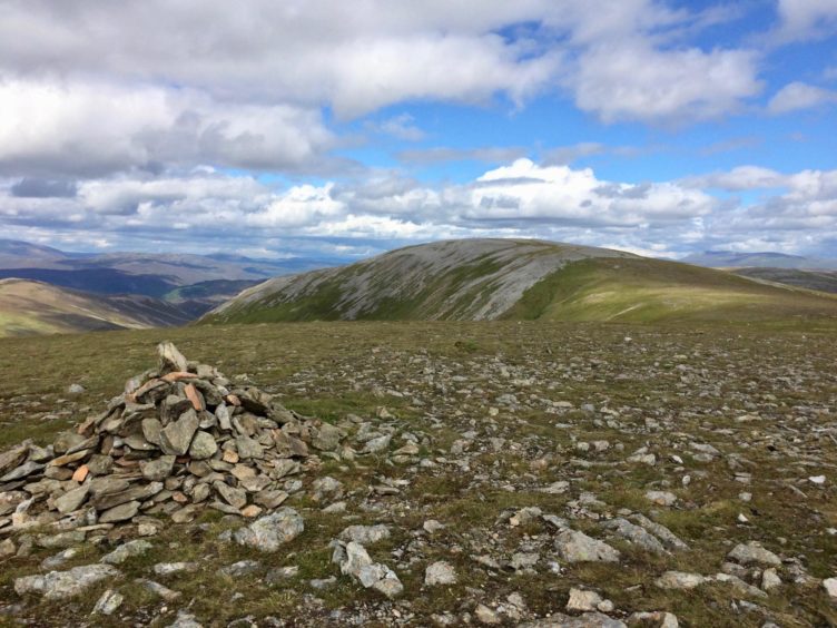
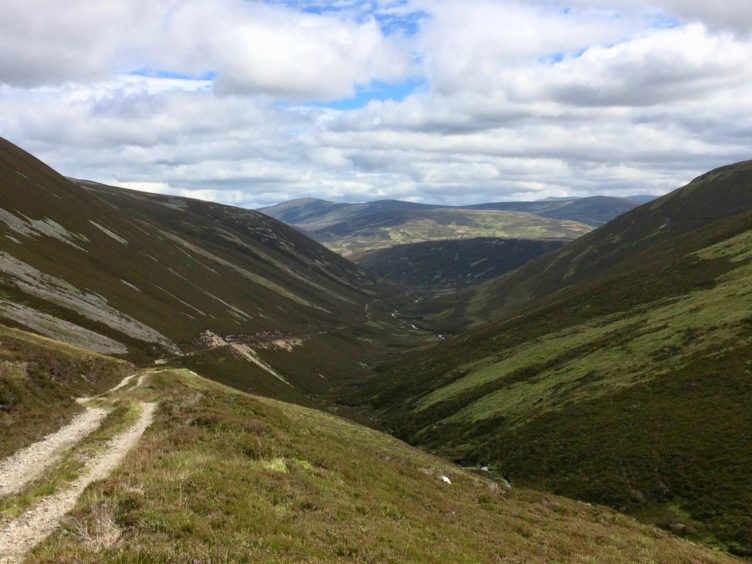
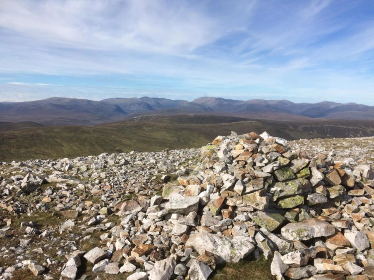
The path makes a short drop then rises again on a crooked line to the south-west top of Carn Bhac, and the untidy cairn of the main summit is less than a kilometre away over increasingly stony ground. The horizon to the north is filled with the bulk of the Cairngorms.
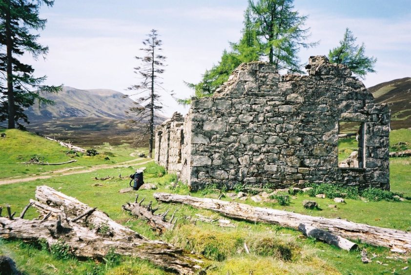
The next target is Altanour Lodge, a once-grand venue for shooting parties, but now just another crumbling ruin. Every time I visit it seems to have deteriorated further. I suspect it won’t be long before there is nothing left, the remaining stones overwhelmed by nature. There are new fenced enclosures to encourage fresh tree growth in a place where cover is sparse. A few skeletons remain standing but the ground is littered with the fallen.
The best way down to the lodge is to stay well above the waters of the Alltan Odhar, crossing over the side of Carn Creagach. Those who haven’t had enough summits for one day can go the top of this hill and then follow the ridge over Creag an Lochain to emerge at Auchelie. The track running past the lodge runs for 7.5km down Glen Ey, crossing a few bridges as it twists and turns all the way back to the car park.
The area below the mountains to the south is offered in some translations as ‘Hell’s glen’ due to the suggestion that walking into this panorama was like entering the gates of Hell, a cold and forbidding place for travellers.
That sense of abandonment runs right through Glen Ey, with numerous, poignant reminders of communities lost. There were crofters at one time, but they became victims of the Clearances. In 1829 five families were moved out to make way for deer, and in 1842 another eight were thrown out along with thousands of cattle and sheep.
A crackdown on whisky distilling further added to the depopulation as some crofters relied on this to supplement their meagre income and, without it, were unable to pay their rent.
There are ruins at Auchelie, standing on the skyline with their sentries out front, two tall larch trees which have survived the fierce winds that have ravaged so much of the tree cover. Beyond this lay the main area of settlements and everywhere there is evidence of former houses, walls and shielings.
The history lesson doesn’t end here. Near the end of the track, there are signposts to The Colonel’s Bed, a slanting shelf in a rocky ravine where John Farquharson, a freebooter known as the Black Colonel, hid from government troops in 1715. Take care if you visit – it can slippery and dangerous in wet conditions.
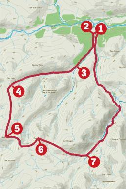
ROUTE
1. Head west along road from parking, pass phone box and cross stone bridge then take track on left heading south.
2. Track passes above some houses and continues south trending south-west to end of treeline.
3. Ignore path going off left, sticking with main track now heading west on gradual rise before ending at high col.
4. Turn left on to follow path, sometimes faint, running south over two minor tops (788m and 801m) and climb to small stony summit of Geal Charn.
5. Descend slightly east and follow path to Carn Bhac’s south-west top before continuing on over stony ground to main summit.
6. Drop east on pathless ground over side of Carn Creagach to reach ruined Altanour Lodge.
7. Follow track from lodge by the Ey Burn, north-east at first then swinging north down Glen Ey for 7.5km back to car park.
INFORMATION
Distance: 24.5km/15 miles
Ascent: 753m/2470ft
Time: 6-8 hours
Grading: Estate tracks, hill paths, some pathless terrain. Long, strenuous walk, sustained ascents, suitable for fit, well-equipped walkers with relevant seasonal hill and navigation skills.
Start/finish: Car parking at Inverey (Grid ref: NO 089892), reached by minor road to Linn of Dee from Braemar.
Map: Ordnance Survey 1:50,000 Landranger Map 43 (Braemar & Blair Atholl); Ordnance Survey 1:25,000 Explorer sheet OL49.
Tourist Information: VisitScotland, Ballater iCentre, Station Square, Ballater, AB35 5QB (Tel 01339 755306).
Public transport: None to start, nearest bus service in Braemar.