Calendar An icon of a desk calendar. Cancel An icon of a circle with a diagonal line across. Caret An icon of a block arrow pointing to the right. Email An icon of a paper envelope. Facebook An icon of the Facebook "f" mark. Google An icon of the Google "G" mark. Linked In An icon of the Linked In "in" mark. Logout An icon representing logout. Profile An icon that resembles human head and shoulders. Telephone An icon of a traditional telephone receiver. Tick An icon of a tick mark. Is Public An icon of a human eye and eyelashes. Is Not Public An icon of a human eye and eyelashes with a diagonal line through it. Pause Icon A two-lined pause icon for stopping interactions. Quote Mark A opening quote mark. Quote Mark A closing quote mark. Arrow An icon of an arrow. Folder An icon of a paper folder. Breaking An icon of an exclamation mark on a circular background. Camera An icon of a digital camera. Caret An icon of a caret arrow. Clock An icon of a clock face. Close An icon of the an X shape. Close Icon An icon used to represent where to interact to collapse or dismiss a component Comment An icon of a speech bubble. Comments An icon of a speech bubble, denoting user comments. Comments An icon of a speech bubble, denoting user comments. Ellipsis An icon of 3 horizontal dots. Envelope An icon of a paper envelope. Facebook An icon of a facebook f logo. Camera An icon of a digital camera. Home An icon of a house. Instagram An icon of the Instagram logo. LinkedIn An icon of the LinkedIn logo. Magnifying Glass An icon of a magnifying glass. Search Icon A magnifying glass icon that is used to represent the function of searching. Menu An icon of 3 horizontal lines. Hamburger Menu Icon An icon used to represent a collapsed menu. Next An icon of an arrow pointing to the right. Notice An explanation mark centred inside a circle. Previous An icon of an arrow pointing to the left. Rating An icon of a star. Tag An icon of a tag. Twitter An icon of the Twitter logo. Video Camera An icon of a video camera shape. Speech Bubble Icon A icon displaying a speech bubble WhatsApp An icon of the WhatsApp logo. Information An icon of an information logo. Plus A mathematical 'plus' symbol. Duration An icon indicating Time. Success Tick An icon of a green tick. Success Tick Timeout An icon of a greyed out success tick. Loading Spinner An icon of a loading spinner. Facebook Messenger An icon of the facebook messenger app logo. Facebook An icon of a facebook f logo. Facebook Messenger An icon of the Twitter app logo. LinkedIn An icon of the LinkedIn logo. WhatsApp Messenger An icon of the Whatsapp messenger app logo. Email An icon of an mail envelope. Copy link A decentered black square over a white square.

Map reveals 20mph plans across Dundee – is your area included?

A consultation has been launched on introducing the lower limit in more parts of the city.

Dundee road with 20mph limit sign.
More roads in Dundee could have a 20mph limit. Image: Mhairi Edwards/DC Thomson

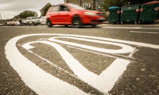
A map has revealed the extent of plans for 20mph zones across Dundee – as a consultation is launched on rolling the reduced limit out to more areas of the city.

About a third of the city’s roads are currently under 20mph restrictions.

That is set to rise to 45% after councillors voted to introduce the limit in further areas including Mains of Claverhouse, Craigiebank and Denhead of Gray.

But the number could increase even further with several other densely-populated areas set to have the limit introduced under council proposals.

Where is latest rollout of 20mph limit in Dundee?

Consultations have been launched on proposals to introduce the 20mph limit in the following areas:

  • Kirkton, St Mary’s and Ardler
  • The Law, the Willows and Ormiston
  • Linlathen Road
  • Mid Craigie and Gotterstone.

The extension of 20mph zones across Dundee is in an attempt to reduce road casualties.

Although there were no deaths on city roads last year, the number of injuries increased.

Map of proposed Dundee 20mph zones

The map, produced by Dundee City Council, shows both existing and proposed 20mph zones.

You can click on the map to reveal its full size.

It shows areas such as central Broughty Ferry, Fintry, Mill o’ Mains, Douglas, Dryburgh and parts of the West End where 20mph zones are already in force.

Map of Dundee with proposed speed limit changes.
Existing and proposed 20mph zones in Dundee (click to reveal full size). Image: Dundee City Council/DC Thomson

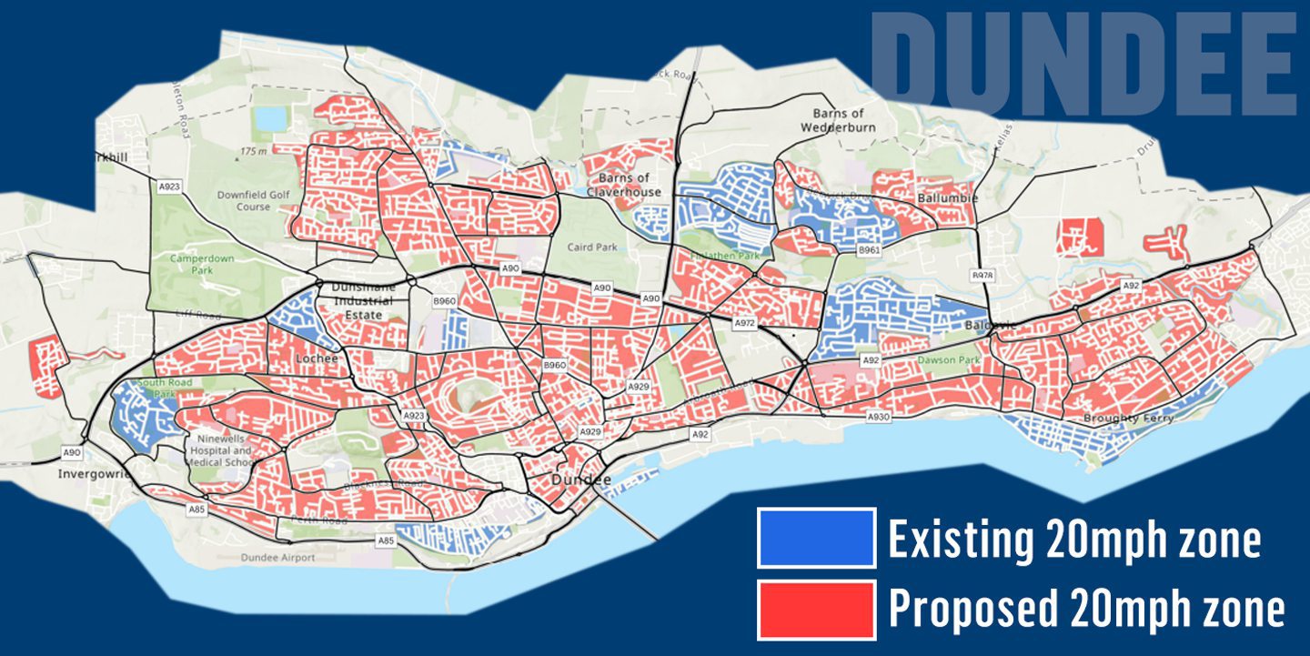
Lower speed limits are planned on most other residential streets across Dundee.

These would not apply to main roads such as the Kingsway.

Charities, such as Brake, believe 20mph should be adopted on all urban roads across the UK.

The limit has already been introduced in some parts of Perth and Kinross, Angus and Fife.

Conversation