Calendar An icon of a desk calendar. Cancel An icon of a circle with a diagonal line across. Caret An icon of a block arrow pointing to the right. Email An icon of a paper envelope. Facebook An icon of the Facebook "f" mark. Google An icon of the Google "G" mark. Linked In An icon of the Linked In "in" mark. Logout An icon representing logout. Profile An icon that resembles human head and shoulders. Telephone An icon of a traditional telephone receiver. Tick An icon of a tick mark. Is Public An icon of a human eye and eyelashes. Is Not Public An icon of a human eye and eyelashes with a diagonal line through it. Pause Icon A two-lined pause icon for stopping interactions. Quote Mark A opening quote mark. Quote Mark A closing quote mark. Arrow An icon of an arrow. Folder An icon of a paper folder. Breaking An icon of an exclamation mark on a circular background. Camera An icon of a digital camera. Caret An icon of a caret arrow. Clock An icon of a clock face. Close An icon of the an X shape. Close Icon An icon used to represent where to interact to collapse or dismiss a component Comment An icon of a speech bubble. Comments An icon of a speech bubble, denoting user comments. Comments An icon of a speech bubble, denoting user comments. Ellipsis An icon of 3 horizontal dots. Envelope An icon of a paper envelope. Facebook An icon of a facebook f logo. Camera An icon of a digital camera. Home An icon of a house. Instagram An icon of the Instagram logo. LinkedIn An icon of the LinkedIn logo. Magnifying Glass An icon of a magnifying glass. Search Icon A magnifying glass icon that is used to represent the function of searching. Menu An icon of 3 horizontal lines. Hamburger Menu Icon An icon used to represent a collapsed menu. Next An icon of an arrow pointing to the right. Notice An explanation mark centred inside a circle. Previous An icon of an arrow pointing to the left. Rating An icon of a star. Tag An icon of a tag. Twitter An icon of the Twitter logo. Video Camera An icon of a video camera shape. Speech Bubble Icon A icon displaying a speech bubble WhatsApp An icon of the WhatsApp logo. Information An icon of an information logo. Plus A mathematical 'plus' symbol. Duration An icon indicating Time. Success Tick An icon of a green tick. Success Tick Timeout An icon of a greyed out success tick. Loading Spinner An icon of a loading spinner. Facebook Messenger An icon of the facebook messenger app logo. Facebook An icon of a facebook f logo. Facebook Messenger An icon of the Twitter app logo. LinkedIn An icon of the LinkedIn logo. WhatsApp Messenger An icon of the Whatsapp messenger app logo. Email An icon of an mail envelope. Copy link A decentered black square over a white square.

Travel warning as snow forecast to hit Tayside and Fife overnight

Post Thumbnail

Snow and ice is forecast to move into Courier Country on both Wednesday and Thursday, with “blizzard conditions” possible on local roads.

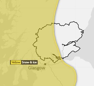
The Met Office has issued a severe “yellow” weather warning for Tayside and Fife from 3am until 6pm tomorrow, with western parts of the region expected to be hit worst.

The forecaster said up to 2in of snow could land on Wednesday morning, with flurries expected at lower levels. Ice is also expected to form on roads.

Angus, eastern parts of Fife, Dundee and Perth are predicted to avoid the worst of the wintry blast early tomorrow.

How the weather warning affects Tayside and Fife

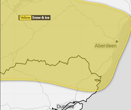
However from Wednesday at 6pm until Thursday at 11am, a separate yellow warning for snow and ice will be in effect for northern areas of Tayside.

The Met Office forecast said snow showers and ice formations are likely into Thursday, with “temporary blizzard conditions” predicted on the highest routes.

The second warning for Tayside, effective from Wednesday night into Thursday morning.

Scotland is expected to be battered by rain, sleet, snow and hail from Wednesday into Thursday.

Wednesday’s first weather warning also stretches to Grampian, the Highlands, the Western Isles, central Scotland, Strathclyde, the south-west, Lothian, the Borders, Orkney and Shetland.

The second one covers Grampian, the Highlands and Islands, the Western Isles and Strathclyde.

A Met Office statement said: “Following a spell of rain, temperatures will fall quickly allowing ice to form on untreated surfaces. Frequent blustery showers of rain, sleet, snow and hail will then also develop.

“Some roads and railways are likely to be affected by snow with longer journey times by road, bus and train services. Some injuries from slips and falls on icy surfaces are also possible.”

The organisation’s chief forecaster said: “2-5 cm (0.8in-2in) of snow is expected to accumulate in places above 200m (656ft).

“Some snow is also possible to low levels at times, mainly overnight. Snow is expected to become confined to higher routes, mainly above 250m (820ft) on Wednesday afternoon.”

Traffic Scotland has warned of snow gate closures, icy patches and issues with visibility on roads.