It’s now almost impossible to imagine a world without the ease of Google Maps, weather forecasts or efficient routes for our home deliveries. These everyday conveniences have shaped our world, and they’ve done so through geospatial technology – a rapidly growing field, transforming various industries.
-
Some Courier online content is funded by outside parties. The revenue from this helps to sustain our independent news gathering. You will always know if you are reading paid-for material as it will be clearly labelled as “Partnership” on the site and on social media channels,
This can take two different forms.
“Presented by”
This means the content has been paid for and produced by the named advertiser.
“In partnership with”
This means the content has been paid for and approved by the named advertiser but written and edited by our own commercial content team.
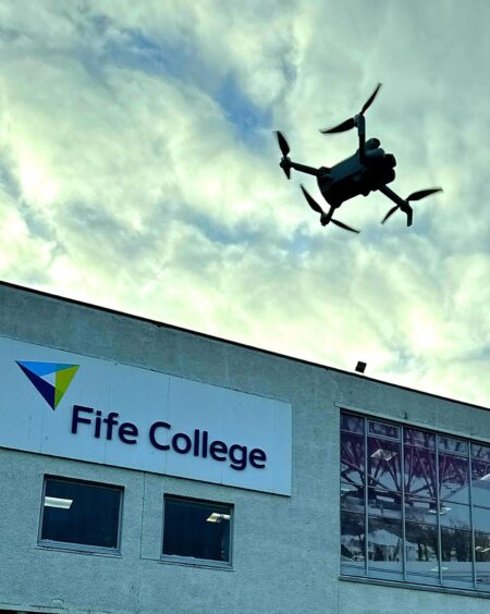
Now, Fife College is offering a pathway into this exciting sector with its new ‘Geospatial Foundation Skills’ course, designed to prepare you for various careers in one of Scotland’s most exciting emerging fields.
And the best part? This course—a UK-first for being delivered at college, as opposed to university—requires no formal qualifications to apply. Whether you’re a school leaver or looking to change career direction, all you need is the determination to take this exciting step towards a new career path and a brighter future.
What are geospatial skills?
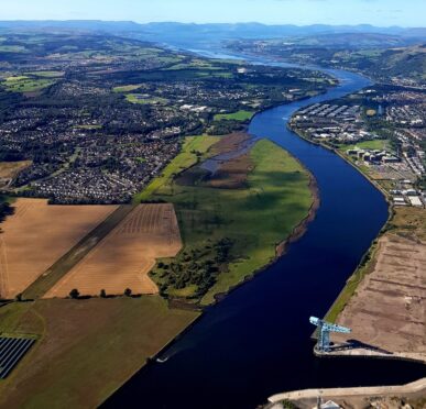
Essentially, geospatial refers to the location-based data used on Earth. It’s about understanding where things happen and how they connect. Geospatial professionals collect and analyse data from sources like satellites, drones and mobile devices to make sense of the world around us.
For example, they might use satellite imagery to monitor deforestation, analyse traffic patterns to optimise transport routes or map areas at risk of flooding to improve disaster response. These skills combine technical know-how with critical thinking, making them incredibly versatile and in-demand across many sectors.
Scotland’s geospatial sector is growing fast, fuelled by the need for location-based insights in industries such as renewable energy, urban planning and conservation and regeneration of our habitat around us. It is a career field where no two days are the same, offering opportunities to address real-world problems and make a meaningful impact to society and the environment.
How does Scotland use geospatial technology?
The application of digital skills is transforming industries in Scotland, and globally, driving innovation and improving efficiency in vital sectors. In renewable energy, geospatial tools play a critical role and, with Scotland looking to lead in clean energy development, these skills are in high-demand.
Geospatial expertise plays a vital role across sectors, from optimising delivery routes and tracking fleet movements in transport and planning to monitoring wildlife habitats, addressing climate change, and conserving natural resources in environmental management. In agriculture, these tools support precision farming, improve crop yields, and minimise environmental impact.
In Fife, geospatial technology will be integral to the development of the Forth Green Freeport – enabling efficient planning, infrastructure management, and environmental monitoring. From mapping renewable energy installations, to optimising transport networks, geospatial skills are essential for creating a sustainable and interconnected hub. The Freeport’s ambitious goals align perfectly with geospatial applications, driving innovation in logistics, green energy and urban planning while supporting Scotland’s low-carbon future.
Alan Corbett, Head of Geospatial with the Scottish Government, said: “This is a fantastic opportunity for anyone looking to start a career in the Tech industry and in particular the Geospatial sector.”
This foundation course is the first of its kind in the UK and will provide a dedicated, supportive, and hands-on learning experience on the use of Geospatial, and how this technology can be used to meet increasing industry demands and create highly-skilled jobs within this established Scottish sector.” – Alan Corbett
Geospatial Foundation Skills at Fife College
Fife College’s Geospatial Foundation Skills course provides an 18-week introduction to this high-demand field. Students use advanced tools like GIS (Geographic Information Systems), satellite imaging, and data analysis, explore the latest surveying technologies, visit low-carbon building sites, investigate river conservation projects, tour satellite design labs and visit one of Scotland’s new spaceports.
Not just for tech enthusiasts, this is an option for anyone curious about how data shapes the world. No prior experience or educational qualifications are required; just a willingness to learn and explore.
Find out more and start your geospatial career now
Fife College is hosting a series of accompanying free webinars to inform about geospatial careers, provide industry insights, answer your questions and demonstrate how this course can launch or transform your career.
Christina MacLeod, Cluster Development project manager at Space Scotland said: “I began my career in the space sector at the age of 21 and I find the industry here in Scotland truly inspiring. I’m deeply passionate about championing ‘women in space’ and am encouraged by the growing number of job opportunities emerging in the geospatial and space sectors.”
With demand for geospatial skills soaring in Scotland, now is the perfect time to enter this thriving field. Whether you’re ready to make a career change or just curious to explore the possibilities, secure your spot in this ground-breaking and unique course.
Visit Fife College’s website to register for a webinar or apply directly for the course today.


Conversation