The Binn, Burntisland, Fife
Anyone passing through Burntisland by train cannot help but notice the impressive lump of rock known as The Binn that towers over the former royal burgh.
Despite only reaching a height of 193m above sea level, it dominates the landscape and serves as a reminder of the volcanic activity that shaped the surrounding area. It also provides a rare opportunity to combine a beach walk with a hill climb.
I had been watching the tide tables, determined to make the most of the wander along the shoreline of the Firth of Forth by going when the water was out.
I exited the parking area at the Links and turned left to the bridge over the railway line before following the road down past the leisure centre to the front. A noticeboard here offers information about the wildlife on the Lammerlaws tidal trail, a short diversion out to the headland.
A left turn took me along to the promenade and then down on to the beach. The sunshine that had greeted my arrival was swallowed by the grey hanging over the firth as I picked my way through damp sand and rocks.
The number of morning strollers had thinned out, and the oppressive combination of ashen sea and sky produced a quiet that was only punctured by the whisper of the distant incoming water being pushed by the wind and the occasional rumble of the trains passing over my head.
As I passed the mass of caravans high above, I spotted a lone kestrel hovering below the cliffs, searching out prey amongst the rocks. It was an unexpected sign of life. So far, I had seen only the corpses of seabirds strewn along the sand ripples, and crows foraging in the pools further out.
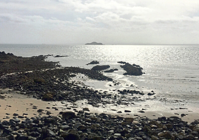
The ill-defined Inchkeith Island was a constant on the horizon dead ahead, but the boats left temporarily high and dry in Pettycur harbour provided a welcome splash of colour and brightness.
I followed the road up into Kinghorn, then turned left and took the ramp leading to the golf course. A rough track went right of the clubhouse then left by the caravan park entrance and past the gates of Grangehill, before dropping down through a farmyard.
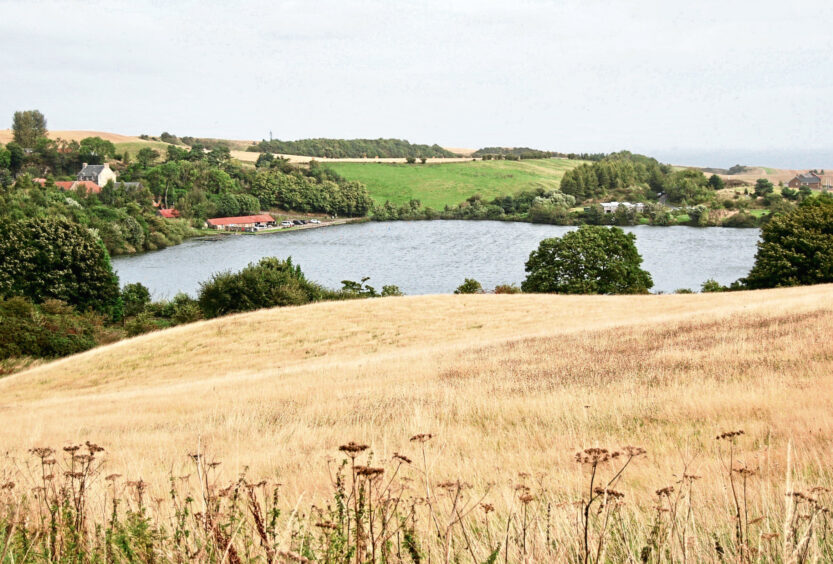
After coming out the other side, I followed the track to its conclusion, the blue of Kinghorn Loch coming into view en route down to the right. With the sun now back in play, I crossed the road and took a signed path snaking between dense vegetation and a high fence, keeping straight on at every junction and passing a picnic area where there were information panels about the local path network, wildlife and the area’s industrial history.
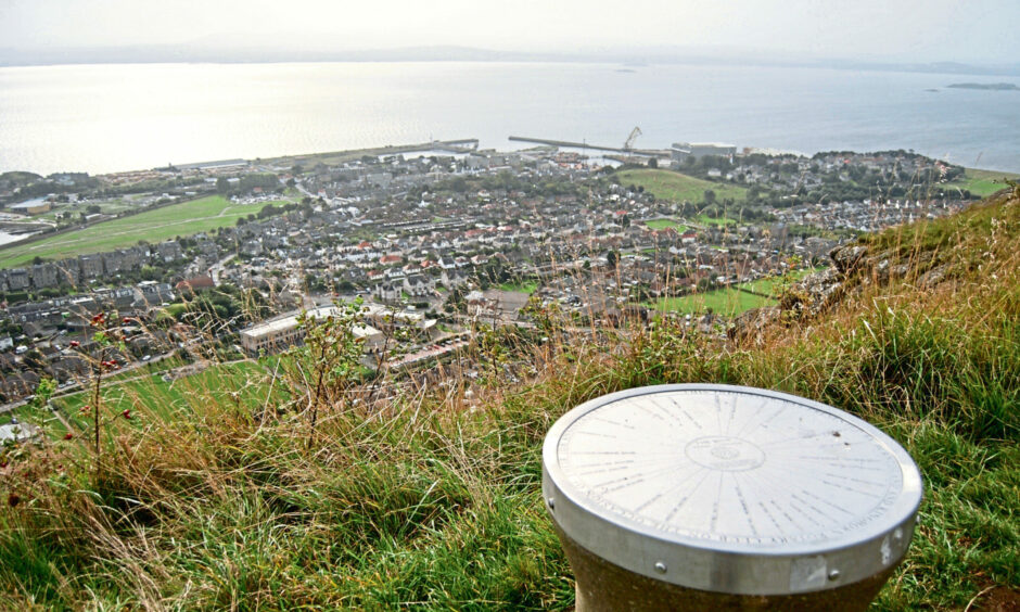
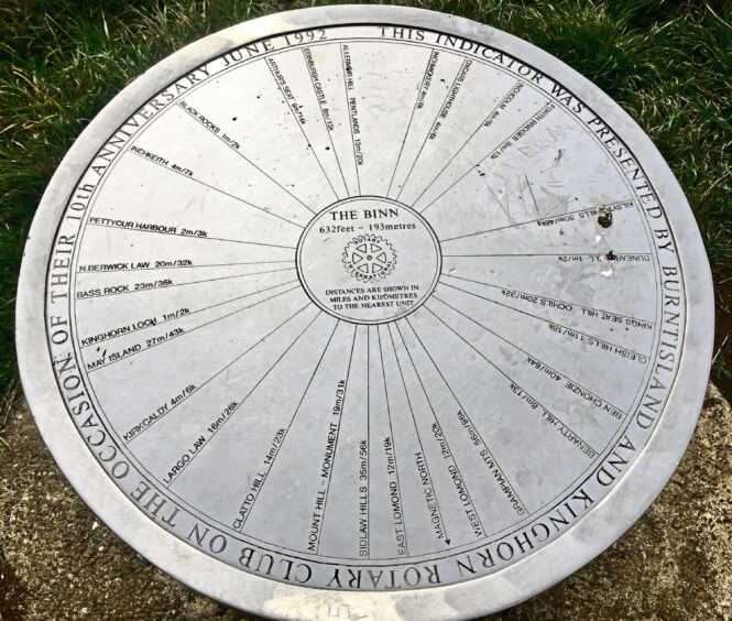
After a couple of stone steps over a wall, the gradient increased and I soon found myself at the summit of The Binn, which houses a direction indicator and a handy bench.
Burntisland lay below like a miniature village, the chatter of everyday life drifting up from the school and the busy streets. Through the haze, I could make out the familiar shape of Arthur’s Seat across the firth, while to the east, the ubiquitous Inchkeith was now framed by the twin prongs of sandbars.
My descent along the line of the cliff edge was enlivened by the sight of a massive silver shimmer in the wheat field — a huge flock of wood pigeons taking flight all at once.
From the side of a small reservoir, a path turns left through a field and a wooded area to emerge on the road (you can also go through the gate by the reservoir, coming out further along). Once on the pavement side, it’s just a case of choosing your preferred route through the streets to the Links.
ROUTE
- Head west out of car park and turn left, crossing bridge over rail line and turning left down Lammerlaws Road and passing leisure centre on right to reach shore.
2. Turn left and head along promenade to its end, where Fife Coastal Path signpost offers high and low tide options.
3. If tide is low, go down on to beach and continue walking east below rail line and then caravan park to reach Pettycur harbour.
4. Follow Pettycur Road round until it reaches main street.
5. Cross road and, a little further on, take ramp uphill on right (signed), passing golf club on right then caravan park entrance on left. Continue on track past Grangehill and then through farmyard and downhill until coming out on B923.
6. Cross road and take Binnend path (signed). Stay on main path, passing picnic area, steadily climbing to summit of The Binn.
7. To descend, continue west on path that drops to small reservoir. Go left at gate taking path through field and then wooded area to emerge on A909.
8. Cross road to pavement side and follow road back past school and down to Links.
Info
Distance: 10km/6.5miles
Ascent: 240m/790ft
Time: 3-4 hours
Grading: Pleasant circuit with one short, steep ascent to suit most abilities using part of Fife Coastal Path, farm tracks and woodland paths. Some road walking, but all on pavements. Can be muddy in places, good footwear advised. Be aware of steep drops on The Binn. Route passes through farmland, dogs under close control.
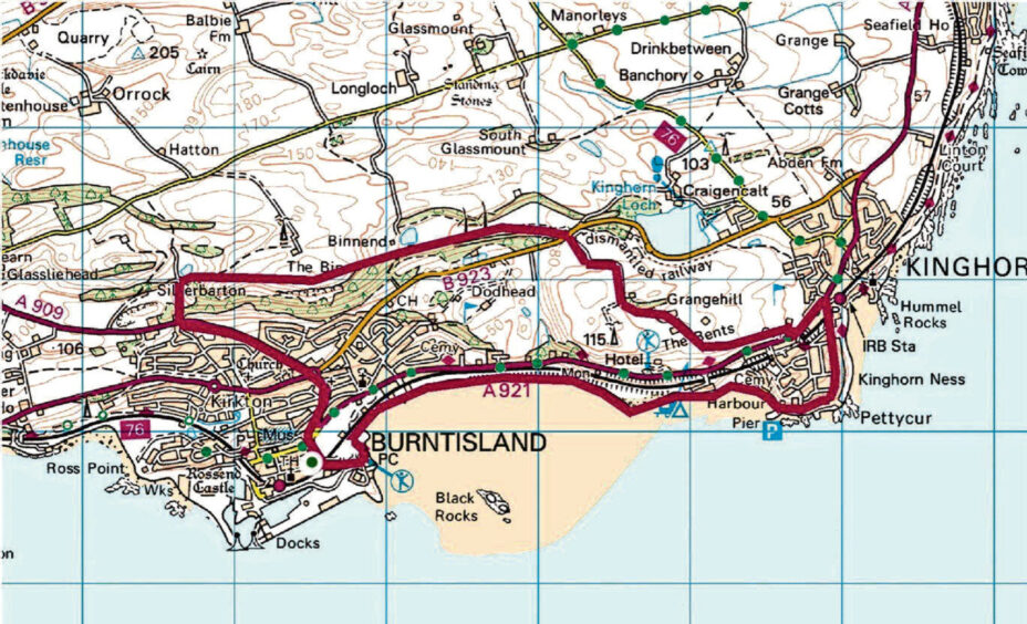
Start/finish: Burntisland Links parking (Grid ref: NT 236860).
Map: Ordnance Survey 1:50,000 Landranger Map 65 (Falkirk & Linlithgow); Ordnance Survey 1:25,000 Explorer sheet 367.
Tourist Information: VisitScotland, St Andrews iCentre, 70 Market Street, St Andrews, KY16 9NU (Tel 01334 472021).