Calendar An icon of a desk calendar. Cancel An icon of a circle with a diagonal line across. Caret An icon of a block arrow pointing to the right. Email An icon of a paper envelope. Facebook An icon of the Facebook "f" mark. Google An icon of the Google "G" mark. Linked In An icon of the Linked In "in" mark. Logout An icon representing logout. Profile An icon that resembles human head and shoulders. Telephone An icon of a traditional telephone receiver. Tick An icon of a tick mark. Is Public An icon of a human eye and eyelashes. Is Not Public An icon of a human eye and eyelashes with a diagonal line through it. Pause Icon A two-lined pause icon for stopping interactions. Quote Mark A opening quote mark. Quote Mark A closing quote mark. Arrow An icon of an arrow. Folder An icon of a paper folder. Breaking An icon of an exclamation mark on a circular background. Camera An icon of a digital camera. Caret An icon of a caret arrow. Clock An icon of a clock face. Close An icon of the an X shape. Close Icon An icon used to represent where to interact to collapse or dismiss a component Comment An icon of a speech bubble. Comments An icon of a speech bubble, denoting user comments. Comments An icon of a speech bubble, denoting user comments. Ellipsis An icon of 3 horizontal dots. Envelope An icon of a paper envelope. Facebook An icon of a facebook f logo. Camera An icon of a digital camera. Home An icon of a house. Instagram An icon of the Instagram logo. LinkedIn An icon of the LinkedIn logo. Magnifying Glass An icon of a magnifying glass. Search Icon A magnifying glass icon that is used to represent the function of searching. Menu An icon of 3 horizontal lines. Hamburger Menu Icon An icon used to represent a collapsed menu. Next An icon of an arrow pointing to the right. Notice An explanation mark centred inside a circle. Previous An icon of an arrow pointing to the left. Rating An icon of a star. Tag An icon of a tag. Twitter An icon of the Twitter logo. Video Camera An icon of a video camera shape. Speech Bubble Icon A icon displaying a speech bubble WhatsApp An icon of the WhatsApp logo. Information An icon of an information logo. Plus A mathematical 'plus' symbol. Duration An icon indicating Time. Success Tick An icon of a green tick. Success Tick Timeout An icon of a greyed out success tick. Loading Spinner An icon of a loading spinner. Facebook Messenger An icon of the facebook messenger app logo. Facebook An icon of a facebook f logo. Facebook Messenger An icon of the Twitter app logo. LinkedIn An icon of the LinkedIn logo. WhatsApp Messenger An icon of the Whatsapp messenger app logo. Email An icon of an mail envelope. Copy link A decentered black square over a white square.

Multi-million-pound strategy to protect hundreds of homes in Highland Perthshire

Flooding in Aberfeldy following Storm Frank in December 2015.

Council bosses have released details of an £8 million flood defences strategy to protect hundreds of “at risk” homes in Highland Perthshire.

Wide-ranging schemes for Pitlochry and Aberfeldy have been proposed after studies revealed nearly 300 houses and 115 businesses could be swamped in the event of a one-in-200 year flood.

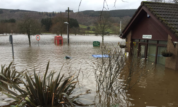
Such an incident caused millions of pounds’ worth of devastation in the east Perthshire town of Alyth just four years ago.

Now Perth and Kinross Council is preparing submissions for SEPA, calling for Pitlochry and Aberfeldy to be included on a national list of priority flood risk areas.

Both schemes are also likely to be included in the next Tay Flood Risk Management Strategy, which is due to be published in December 2021.

Consultants were tasked by the local authority to carry out flood studies in both towns.

In Pitlochry, engineering firm Aecom found that 155 residential properties and 75 commercial buildings were at risk during a one-in-200 year flood.

Action proposed includes removing a watercourse diversion between the upper reaches of the Kinnaird Burn and the Moulin Burn, and creating “woody debris structures” or “tree traps” to reduce the risk of bridges and culverts being blocked further downstream.

Flood walls are also proposed on the eastern bank of the Moulin Burn, at Kirkmichael Road, and on the eastern bank of the Kinnaird Burn at Blair Atholl distillery.

However, Aecom ruled out flood defences on the River Tummel which they found would require a wall of more than two metres high which residents were unlikely to go for.

The work in Pitlochry would cost around £2.73 million.

Consultant engineers from the RPS Group carried out a similar study in Aberfeldy last year.

They found 128 homes and 40 commercial premises would be at risk during extreme flooding.

A £5.3 million action plan for the area includes around a kilometre of new walls at Tayside Place, Tayside Crescent and along the Moness Burn, and a flood embankment next to the former slaughterhouse in Appin Place.

Members of the council’s environment and infrastructure committee will be asked on Wednesday to approve the proposals and have details submitted to SEPA.

Both schemes are likely to be funded by the council and the Scottish Government.