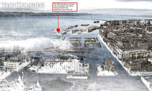
Dramatic images show how the sea could swallow local landmarks such as the Dundee Waterfront in 30 years’ time.
Flooding could engulf attractions including the V&A Dundee and Discovery Point.
That is the grim prediction of climate news organisation Climate Central, which has produced an interactive flood map of how the UK could look in 2050.
Local landmarks submerged
Our graphics — based on the information contained in the maps — demonstrate how flooding could swamp local landmarks.
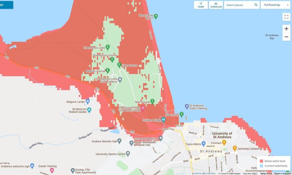
Dundee’s waterfront and a significant part of St Andrews, including the historic Old Course, could be claimed by flooding over the next few decades.
Officials have built a £7 million flood defence scheme at Dundee’s waterfront. It is said to provide a “one-in-200-year standard of protection”.
The Dundee defences should be able to withstand an exceptional flooding event which has a likelihood of happening once in a 200 year period.
However, the defences were rendered useless last year after the flood gates were left open.
Fears for famous Old Course
In Fife, the maps show much of the historic Old Course, including the famous Swilken Bridge, at St Andrews lost to rising sea levels.
Interactive flood maps provided by the Scottish Environment Protection Agency (Sepa) also highlight Dundee Waterfront, St Andrews and a large swathe of Broughty Ferry as at risk of flooding.
Around £15.5m is being spent on flood defences at Broughty Ferry.
The project will transform the appearance of the coastline. However, it has been deemed essential after worsening flooding incidents in recent years.
Although countries may not be able to protect every location, they can create more time to plan and build defences.”
Benjamin Strauss, CEO of Climate Central
Benjamin Strauss is chief scientist and CEO of Climate Central.
He said: “Our maps show planners where the risks may be most acute, prompting the collection of precise, onsite measurements. This can guide plans to protect these places.
“In Scotland, SEPA flood maps may offer further guidance based on regional data.
“Every site is different, so some may be defended with sea walls or wetlands restoration, while others may be better suited to adaptations like elevating buildings and roads.
“Although countries may not be able to protect every location, they can create more time to plan and build defences by cutting carbon emissions as much and as soon as possible. This will slow the rate of global heating and sea level rise.”
Preventing flooding in Dundee and Fife
Dr Andrew Black is a reader in environmental science at Dundee University. He said techniques for mapping flood risk had become more sophisticated in recent decades.
“It must be 20 years or so since we first had flood risk maps for Scotland.
“Methods have been through a series of improvements, input data have been improved and climate change has become an increasing concern and a focus of increasing research.”
Rising sea levels mean councils will have to continue to invest in flood prevention schemes amid budget pressures.
Dr Black said: “I think there is quite a lot that local authorities and others are already doing. But of course there will inevitably be more to do.
“Events do tend to galvanise – but with flooding, after the event is not the best time for action.
“There is some good news. This is in the form of an increase in Scottish Government funding to assist flood risk management in the last budget.
“But there is a long way to go before no-one is left at risk of flooding.”