Rotmell Wood, Dunkeld, Perth & Kinross
The woodlands above Dunkeld are a favourite stomping ground that offer a fresh choice of route for each day of the week on a fine network of paths and tracks.
This particular anti-clockwise circuit from the Cally car park takes in a whole series of little lochs sprinkled throughout a beautifully rugged landscape of heather, tree and crag.
The initial approach will be familiar for those heading for Deuchary Hill and Loch Ordie, as it passes Cally Loch, Hatton and then Birkenburn en route to The Glack. Instead of turning right at the busy signpost at the southern tip of Mill Dam, our route goes straight on along the western side of the water.
Before continuing however, it’s worth pausing to examine the work of the local beavers who have created a couple of small dams off to the right. Mill Dam is also a good spot to catch sight of swans, ducks and other waterfowl.
Once past the end of the water, the tree cover starts to thin and there is a greater feeling of space for a short interlude. The first signed track on the left should be ignored – this eventually links up with our route anyway – in preference to the next one leading into Rotmell Wood.
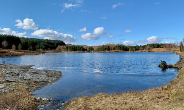
Before disappearing into the trees, it’s better to walk ahead a few steps to visit the shores of Rotmell Loch, a pine-fringed blue oasis which would be a fine spot for a lunch stop. Those who are keen to add to their lochs tick list can also keep on for another kilometre to reach Dowally Loch.

Backtracking now, the path into the trees is a little coarse and dark at first but it soon develops into a solid throughway. At one point, there is curious ramp of large rocks off to the left of the main line presumably to aid the passage of motorised transport.
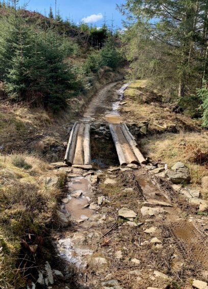
There are some heavily waterlogged sections which necessitate some nimble footwork at times, while placed logs help out at others. The path eventually dropped to reach a forest road, a left turn leading along past small quarries and cleared slopes to join another track which I followed right.
This led over a minor rise and then started dropping in a wide sweep, right at first then back left, to link with a track running south high above the parallel lines of the Tay and the A9. This can be followed for some three kilometres to join the road at the King’s Pass, but there are opportunities to extend the day along the way.

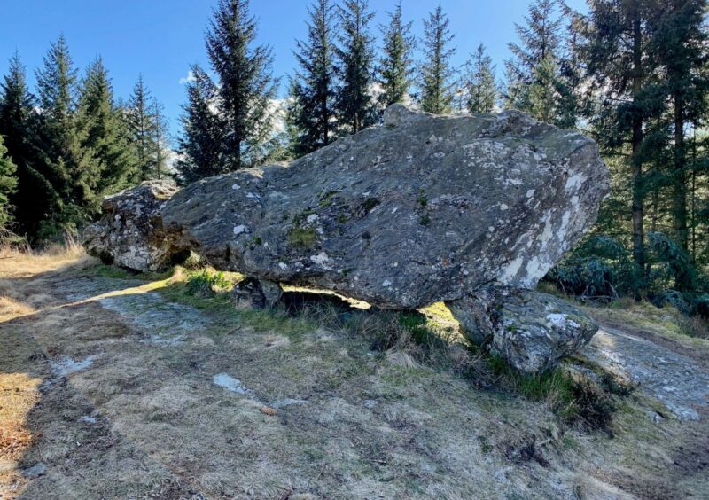
I took one of the woodland paths heading off left into the trees, climbing steadily to find the outlandish Rocking Stone, a huge boulder seemingly perfectly balanced on half a dozen smaller rocks which sits atop a crag.
I then followed a path deeper into the trees to reach a cairn at the top of Craig a Barns but was careful not to venture too much further south. Directly below is the precipitous Polney Crag, and off to the left is Lover’s Leap, whose name should be enough of a clue to its danger.
Instead, I dropped back out of the trees to the main track and then made the short walk along the road before re-entering the wood beside the final body of water of the day, sparkling Polney Loch.
There’s one final choice. When the path splits just beyond the loch, you can either go right past the sawmill and straight back to the car, or make the short ascent left on the higher line for a glimpse of the caves which sit amongst the boulder chaos on the left.
ROUTE
1. Head back out of car park and turn left almost immediately on to Atholl Estates track, signed for Mill Dam and Upper Hatton.
2. Ignore first track going right, then at fork keep right alongside fence past Hatton. Track cuts sharply round Birkenburn before turning back north towards The Glack.
3. Go through metal gate and walk round to Mill Dam. Stay on track with water on your right. Ignore track branch going left a little further on but take next left heading into Rotmell Wood. NB: it’s worth walking on a short distance to see Rotmell Loch before turning back for the path.
4. Path through the trees is rocky in places and waterlogged in others. Don’t take side path going uphill into trees (this leads back round towards Mill Dam) but instead turn left on track further on at junction.
5. Swing right at next junction, then right again heading steadily downhill to reach track running south and follow for 3km to exit on to minor road under Polney Crag.
6. Turn right and walk along verge to Polney Loch. Take path on east side of loch into woods.
7. When path splits, take left branch climbing uphill. Turn right at next path junction, passing caves on hillside before emerging at car park.

INFORMATION
Distance: 12km/7.5miles
Ascent: 393m/1290ft
Time: 2.5-3.5 hours
Grading: Well-signed woodland circuit on good tracks and paths with some moderate ascent, suitable for most levels of age, ability and fitness. Rough, rocky and muddy in places, also waterlogging on some path sections, sturdy footwear recommended. One short section along road verges needs care.
Start/finish: Cally car park off A923 (Grid ref: NO 023437) one kilometre north of Dunkeld, second lane on left.
Map: Ordnance Survey 1:50,000 Landranger Map 53 (Blairgowrie & Forest of Alyth); Ordnance Survey 1:25,000 Explorer sheet 379.
Tourist Information: VisitScotland, Pitlochry iCentre, 22 Atholl Road, Pitlochry, PH16 5BX (Tel 01796 472215).
Public transport: Bus and train services to Dunkeld.
Conversation