Calendar An icon of a desk calendar. Cancel An icon of a circle with a diagonal line across. Caret An icon of a block arrow pointing to the right. Email An icon of a paper envelope. Facebook An icon of the Facebook "f" mark. Google An icon of the Google "G" mark. Linked In An icon of the Linked In "in" mark. Logout An icon representing logout. Profile An icon that resembles human head and shoulders. Telephone An icon of a traditional telephone receiver. Tick An icon of a tick mark. Is Public An icon of a human eye and eyelashes. Is Not Public An icon of a human eye and eyelashes with a diagonal line through it. Pause Icon A two-lined pause icon for stopping interactions. Quote Mark A opening quote mark. Quote Mark A closing quote mark. Arrow An icon of an arrow. Folder An icon of a paper folder. Breaking An icon of an exclamation mark on a circular background. Camera An icon of a digital camera. Caret An icon of a caret arrow. Clock An icon of a clock face. Close An icon of the an X shape. Close Icon An icon used to represent where to interact to collapse or dismiss a component Comment An icon of a speech bubble. Comments An icon of a speech bubble, denoting user comments. Comments An icon of a speech bubble, denoting user comments. Ellipsis An icon of 3 horizontal dots. Envelope An icon of a paper envelope. Facebook An icon of a facebook f logo. Camera An icon of a digital camera. Home An icon of a house. Instagram An icon of the Instagram logo. LinkedIn An icon of the LinkedIn logo. Magnifying Glass An icon of a magnifying glass. Search Icon A magnifying glass icon that is used to represent the function of searching. Menu An icon of 3 horizontal lines. Hamburger Menu Icon An icon used to represent a collapsed menu. Next An icon of an arrow pointing to the right. Notice An explanation mark centred inside a circle. Previous An icon of an arrow pointing to the left. Rating An icon of a star. Tag An icon of a tag. Twitter An icon of the Twitter logo. Video Camera An icon of a video camera shape. Speech Bubble Icon A icon displaying a speech bubble WhatsApp An icon of the WhatsApp logo. Information An icon of an information logo. Plus A mathematical 'plus' symbol. Duration An icon indicating Time. Success Tick An icon of a green tick. Success Tick Timeout An icon of a greyed out success tick. Loading Spinner An icon of a loading spinner. Facebook Messenger An icon of the facebook messenger app logo. Facebook An icon of a facebook f logo. Facebook Messenger An icon of the Twitter app logo. LinkedIn An icon of the LinkedIn logo. WhatsApp Messenger An icon of the Whatsapp messenger app logo. Email An icon of an mail envelope. Copy link A decentered black square over a white square.

Met Office issues multiple local weather warnings with wind, rain, ice and snow forecast

Parts of Courier Country are subject to weather warnings for wind, rain and ice.

As much as 6cm of snow could also fall as the wet weather gives way to colder conditions from tonight.

The Met Office weather forecast for Scotland is in the video above this article.

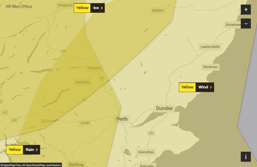
The Courier reported yesterday that the Met Office had issued a yellow weather warning for strong winds on Tuesday across all of Perthshire, Fife, Dundee and Angus.

Met Office warns of travel disruption in Courier Country as wind gusts of 70mph forecast

The warning, valid from 5am to 5pm, coincides with warnings for rain and ice across parts of the region.

The warning for rain affects southern and western parts of Perthshire, including Auchterarder, Crieff, Aberfeldy, Pitlochry and the very edge of Perth.

It is valid until 3pm Tuesday. The warning says: “Rain, heavy at times will cross Scotland during Tuesday accompanied by strong and gusty winds. Rainfall accumulations widely 20 to 40mm locally 60mm over high ground of western Scotland. Much of the rainfall will occur in a short time period.

“Winds will gust widely 40 to 50mph inland with 60mph possible in coastal areas: a separate wind warning has been issued for part of this area.

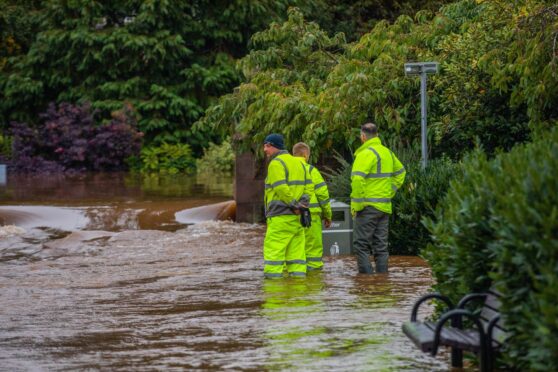
“Bus and train services probably affected with journey times taking longer. Flooding of a few homes and businesses is likely.”

The yellow warning for ice affects northern and western parts of Perthshire, including Aberfeldy and Pitlochry.

It is valid from 10pm Tuesday until 10am Wednesday. The warning says: “Icy patches are likely to develop during Tuesday night as frequent blustery, heavy showers of rain and hail fall onto cold surfaces, especially untreated roads and pavements.

“Meanwhile, above 200 metres elevation, showers will fall as snow at times, perhaps with 2-6 cm of snow above 400 metres, blown along by strong, gusty winds.”

Blustery conditions have been reported across the region, with gusts of up to 70mph forecast.

The warning for wind, currently in place, says: “Very strong south to southwesterly winds are expected to develop across parts of Wales, England and Scotland during Tuesday.

“Winds will strengthen through the morning with gusts of 50-60 mph likely inland, and 60-70 mph around some coasts and over higher ground.

“The strongest winds will probably occur ahead of an intense band of rain that is expected to move quickly eastwards during the day, winds easing once this clears.

“Some delays to road, rail, air and ferry transport are likely.

“Probably some bus and train services affected, with some journeys taking longer, made worse by spray and surface water.

“Delays for high-sided vehicles on exposed routes and bridges likely. Some short term loss of power and other services is possible.”

The warnings come as the local area braces itself for a bout of wintry weather on general election day.

Voting fears as snow forecast to arrive in Scotland for general election