Calendar An icon of a desk calendar. Cancel An icon of a circle with a diagonal line across. Caret An icon of a block arrow pointing to the right. Email An icon of a paper envelope. Facebook An icon of the Facebook "f" mark. Google An icon of the Google "G" mark. Linked In An icon of the Linked In "in" mark. Logout An icon representing logout. Profile An icon that resembles human head and shoulders. Telephone An icon of a traditional telephone receiver. Tick An icon of a tick mark. Is Public An icon of a human eye and eyelashes. Is Not Public An icon of a human eye and eyelashes with a diagonal line through it. Pause Icon A two-lined pause icon for stopping interactions. Quote Mark A opening quote mark. Quote Mark A closing quote mark. Arrow An icon of an arrow. Folder An icon of a paper folder. Breaking An icon of an exclamation mark on a circular background. Camera An icon of a digital camera. Caret An icon of a caret arrow. Clock An icon of a clock face. Close An icon of the an X shape. Close Icon An icon used to represent where to interact to collapse or dismiss a component Comment An icon of a speech bubble. Comments An icon of a speech bubble, denoting user comments. Comments An icon of a speech bubble, denoting user comments. Ellipsis An icon of 3 horizontal dots. Envelope An icon of a paper envelope. Facebook An icon of a facebook f logo. Camera An icon of a digital camera. Home An icon of a house. Instagram An icon of the Instagram logo. LinkedIn An icon of the LinkedIn logo. Magnifying Glass An icon of a magnifying glass. Search Icon A magnifying glass icon that is used to represent the function of searching. Menu An icon of 3 horizontal lines. Hamburger Menu Icon An icon used to represent a collapsed menu. Next An icon of an arrow pointing to the right. Notice An explanation mark centred inside a circle. Previous An icon of an arrow pointing to the left. Rating An icon of a star. Tag An icon of a tag. Twitter An icon of the Twitter logo. Video Camera An icon of a video camera shape. Speech Bubble Icon A icon displaying a speech bubble WhatsApp An icon of the WhatsApp logo. Information An icon of an information logo. Plus A mathematical 'plus' symbol. Duration An icon indicating Time. Success Tick An icon of a green tick. Success Tick Timeout An icon of a greyed out success tick. Loading Spinner An icon of a loading spinner. Facebook Messenger An icon of the facebook messenger app logo. Facebook An icon of a facebook f logo. Facebook Messenger An icon of the Twitter app logo. LinkedIn An icon of the LinkedIn logo. WhatsApp Messenger An icon of the Whatsapp messenger app logo. Email An icon of an mail envelope. Copy link A decentered black square over a white square.

School traffic exclusion zones: Where are they and where could they be introduced?

There are a number of school traffic exclusion zones across Courier Country. Pic: Kim Cessford / DCT Media

School traffic exclusion zones are currently operating in a number of streets across Courier Country.

The aim of the driving bans near schools in Angus, Perthshire and Dundee is to make the commute safer for children while encouraging active travel.

The introduction of the Safer School Streets scheme aims to offer other benefits too including: reducing traffic speed, cutting down on traffic congestion and reducing air pollution near schools.

The aim of the school traffic exclusion zones in Angus, Perthshire and Dundee is to make the commute safer for children while encouraging active travel.

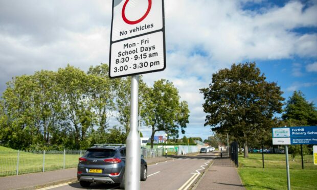
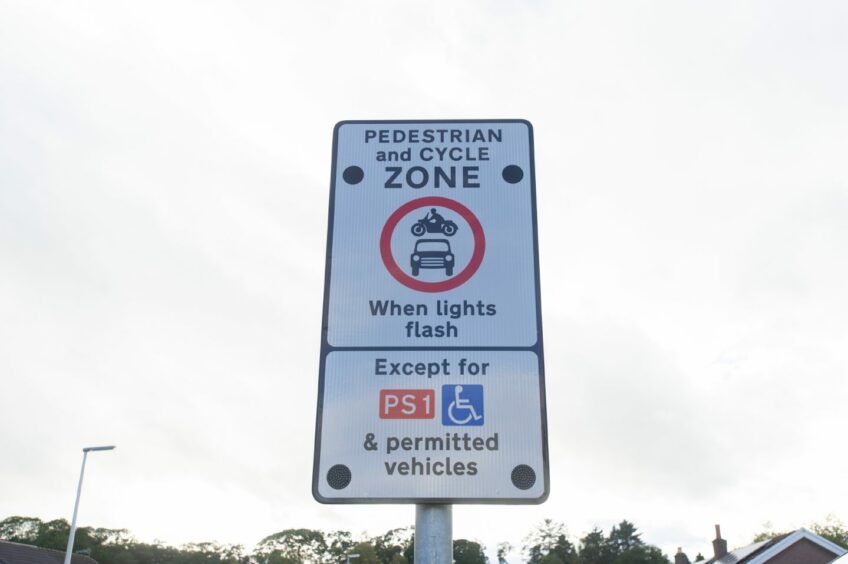
The initiative sees certain streets around schools being closed to traffic during school term time only, each morning and afternoon at school opening and closing times.

But where are school exclusion zones currently operating and where could more be added? See our map at the bottom for details of streets affected.

Existing school exclusion zones

Angus

Perth and Kinross

  • Burrelton Primary School, Blairgowrie
  • Coupar Angus Primary School, Blairgowrie
  • Arngask Primary School, Glenfarg
  • Luncarty Primary School
  • At Balhousie Primary, Perth
  • At Kinloch Rannoch Primary, Pitlochry
  • At Inchview Primary, Perth
  •  At Newhill Primary and St Stephen’s RC Primary, Blairgowrie
  • At Guildtown Primary, Guildtown
  • Viewlands Primary, Fairview School and Perth Academy, Perth

Dundee

  •  Forthill Primary School, Broughty Ferry
  • St Mary’s Primary School,  Lochee
  • Fintry Primary School

Where could school exclusion zones be added?

Perth

This zone is expected to be added in 2022/23. The launch of the scheme has been deferred until improvements have been made to the road infrastructure for pedestrians.

School traffic exclusion zones aim to tackle the problem of cars parking near schools.

Dundee

A statutory consultation is currently ongoing on extending the Safer School Streets initiative to these five schools:

  • Downfield Primary
  • Craigiebarns Primary
  • North East Campus (Longhaugh Primary and St Francis RC Primary)
  • Coldside Campus (Rosebank Primary and Our Lady’s RC Primary)
  • St Andrews RC Primary

Discussions have also taken place to extend the scheme to nine more primary schools in Dundee. They are:

  • Ardler & St Fergus Primary Schools
  • Barnhill Primary School
  • Claypotts Castle Primary School
  • Clepington Primary School
  • Craigowl Primary School
  • Eastern Primary School
  • Mill of Mains Primary School
  • St Ninians Primary School
  • St Pius Primary School
Work is at an advanced stage for the pilot at Denend Primary in Cardenden. Pic: Steve Brown / DCT Media

Fife

Work is at an advanced stage for the pilot at Denend Primary in Cardenden. The statutory consultation on this school exclusion zone closed on August 16, 2022.

Other Fife schools being looked at are:

  • Pitcoudie Primary School, Glenrothes
  • St Marie’s Primary School, Kirkcaldy.


School traffic exclusion zones: What do parents and councils think?

Conversation